
Tamil Nadu land records
CMDA Land Use Map for the Chennai Metropolitan Area (சிஎம்டிஏ நில பயன்பாட்டு வரைபடம்)
A CMDA Land Use Map is the sheet CMDA publishes for part of the Chennai Metropolitan Area, showing the planned land-use zones and a legend of zone categories. Pick the local body type, the local body name and the village name. Checking costs nothing; you pay only once the sheet is ready.
Search the record
Fetching your record
Usually done in under 30 seconds.
Keep this tab open while we fetch your record.
What we're fetching
Progress
0:00
Your order
Result
You have not been charged. ₹0.
Not sure of the survey number?
Tap the map or paste a Maps link into the Survey Number Finder. It shows the survey number it has for that point, when it has one.
Find it on the map Survey Number Finder · opens in a new tabChecking is free, and nothing found means nothing charged: you pay only for a complete, readable record.
Why View Patta?
- No record, no charge Not found? Your money stays yours.
- Full refund, guaranteed Automatic if we can’t deliver.
- 180-day access Download it again any time.
- Straight from the government Direct from the source.
Use cases
- Seeing the zones CMDA has planned for the area around a plot in the Chennai Metropolitan Area
- Reading a sheet’s legend to see which zone categories it uses
- Having CMDA’s own sheet to hand when you ask CMDA to confirm the zoning of a plot
Overview
CMDA Land Use Map overview
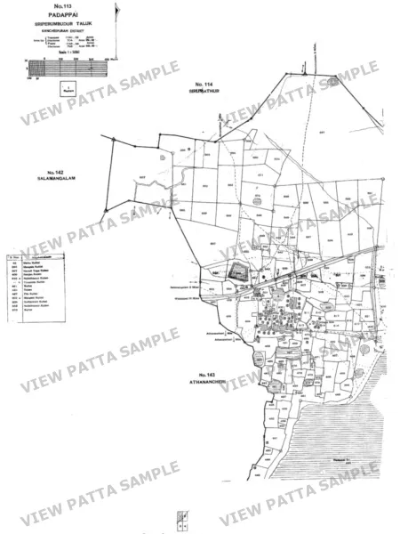
A CMDA Land Use Map (சிஎம்டிஏ நில பயன்பாட்டு வரைபடம்) is one sheet of the land use map that the Chennai Metropolitan Development Authority (CMDA) publishes for part of the Chennai Metropolitan Area, from its Second Master Plan. It shows the planned land-use zones for that part of the area, with a legend of zone categories. On the sample sheet the legend lists primary residential, mixed residential, commercial, institutional, industrial, special and hazardous industrial, urbanisable, non urban, water body, reserved forest, continuous building area and EWS area; the categories vary by sheet. You choose the sheet by local body type (Corporation, Municipality, Town Panchayat or Panchayat Union), then the local body name, then the village name as CMDA lists it, such as “Adayar (MP)”. No survey number is asked for. View Patta fetches the sheet from CMDA when you order and delivers it as a PDF: CMDA’s sheet exactly as published, and a closing page. Large sheets keep their size, often about 0.9 m by 1.2 m, and some sheets are A4. This is an information copy of a published map, not a CMDA land use certificate, not proof of ownership and not a planning or building approval. Zoning for a specific plot is confirmed only by CMDA.
Record guide
What do the terms mean?
- Master plan
- CMDA’s plan for land use across the Chennai Metropolitan Area. This map is drawn from its Second Master Plan.
- Land use zone
- The use the plan sets for an area, such as residential, commercial or industrial. The legend on each sheet names the zones it shows.
- Legend
- The key to the colours and patterns on the sheet. Categories vary by sheet, so read the legend of the sheet you receive.
- Local body
- A Corporation, Municipality, Town Panchayat or Panchayat Union. The sheet list is grouped by local body.
- Variation
- A change to the master plan, notified in the gazette. A sheet may predate later variations, so ask CMDA for the current zoning.
Troubleshooting
Why might the result not appear?
- The sheet is expected to confirm the zoning of one plot, but only CMDA confirms that.
- The sheet predates a later variation, so the zone it shows has since changed.
- The area you care about is not on the sheet you chose. Each order is for one sheet, so another sheet is a separate order.
- The legend is read as if it were the same on every sheet, but the categories vary by sheet.
- The map is expected to be a land use certificate, but it is CMDA’s published map and not a certificate.
What this record cannot establish
A CMDA Land Use Map is an information copy of CMDA’s published map sheet. It is not a CMDA land use certificate, not proof of ownership and not a planning or building approval, and CMDA says its published content should not be construed as a statement of law. Zoning for a specific plot is confirmed only by CMDA. A sheet may also predate later amendments, which are variations notified in the gazette, so check with CMDA for the current zoning before relying on it. Use the Patta Chitta for a parcel’s recorded holder.
Verification checklist
How to use this record
- Choose the local body type, the local body name and the village name that covers your area, as CMDA lists them.
- Open the PDF and read the legend on the sheet, since the zone categories vary by sheet.
- Find your area on the sheet and note the zone shown there.
- Remember that the sheet may predate later variations notified in the gazette.
- Ask CMDA to confirm the zoning of your specific plot before you rely on it.
Search help
What details should you keep ready?
Choose the local body type, then the local body name, then the village name as CMDA lists it, such as “Adayar (MP)”. No survey number is needed.
Guides
Read before you search
Related tools
Continue checking the property
Questions
Before you start.
Including the two most people ask: whether we are the government, and what happens if the record is not there.
What is a CMDA Land Use Map?
A CMDA Land Use Map is one sheet of the land use map that CMDA publishes for part of the Chennai Metropolitan Area, from its Second Master Plan. It shows the planned land-use zones and a legend of zone categories.
Is it a CMDA land use certificate?
No. It is CMDA’s published map sheet, not a certificate, and not proof of ownership or a planning or building approval. CMDA says its published content should not be construed as a statement of law. The sheet comes from CMDA at cmdachennai.gov.in; View Patta is not affiliated with CMDA or the government.
Which sheet do I need, and how do I find my area?
Start with the local body your land is in. Choose the local body type (Corporation, Municipality, Town Panchayat or Panchayat Union), then the local body name, then the village name as CMDA lists it, such as “Adayar (MP)”. Each order is for one sheet.
Does the sheet confirm the zoning of my plot?
No. The sheet shows the planned zones for the area it covers. Zoning for a specific plot is confirmed only by CMDA. A sheet may also predate later variations to the plan, which are notified in the gazette, so check with CMDA for the current zoning.
What if the sheet is not available?
View Patta fetches the sheet from CMDA when you order. If neither CMDA nor our stored copy can supply the sheet, or CMDA serves a page with no map, the order ends and you are not charged. Checking costs nothing, and a price appears only once the sheet is ready.
What do I receive, and at what size?
A PDF with CMDA’s sheet exactly as published, and a closing page. Large sheets keep their published size, often about 0.9 m by 1.2 m, and some sheets are A4. It is an information copy, not a certified copy.
Is View Patta a government website?
No. View Patta is a private service operated by Quiro Tech Solutions, Chennai. We are not affiliated with any government body. Revenue-record services are available through Tamil Nadu e-Services; Encumbrance Certificates are registration records available through TNREGINET. View Patta provides separate assistance with finding and requesting these records.
What happens if you cannot find my record?
No record, no charge. Your money stays yours.
For a single record we look first and only ask for payment once we hold a complete, readable record for your survey number. If the portal has no record, returns something incomplete, or does not respond, you see exactly what happened and you are not charged.
A village report is paid for first, because it is compiled after you order. If it cannot be compiled, the payment is refunded in full, automatically.