
Tamil Nadu land records
Block Map for a Tamil Nadu Town (பிளாக் வரைபடம்)
A Block Map shows every town survey number in one block of a Tamil Nadu town on a single cadastral map, so you can see where an urban plot sits among its streets and neighbouring plots. Pick the district, taluk, town, ward and block. Checking costs nothing; you pay only once the map sheets are ready.
Search the record
Getting your map ready
We're preparing the map sheets for this place.
Keep this tab open while we prepare your map.
What we're preparing
Progress
0:00
Your order
Result
You have not been charged. ₹0.
Not sure of the survey number?
Tap the map or paste a Maps link into the Survey Number Finder. It shows the survey number it has for that point, when it has one.
Find it on the map Survey Number Finder · opens in a new tabChecking is free, and nothing found means nothing charged: you pay only for a complete, readable record.
Why View Patta?
- No record, no charge Not found? Your money stays yours.
- Full refund, guaranteed Automatic if we can’t deliver.
- 180-day access Download it again any time.
- Straight from the government Direct from the source.
Use cases
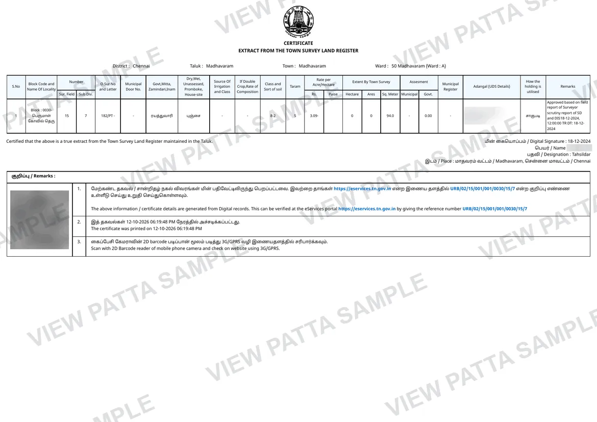
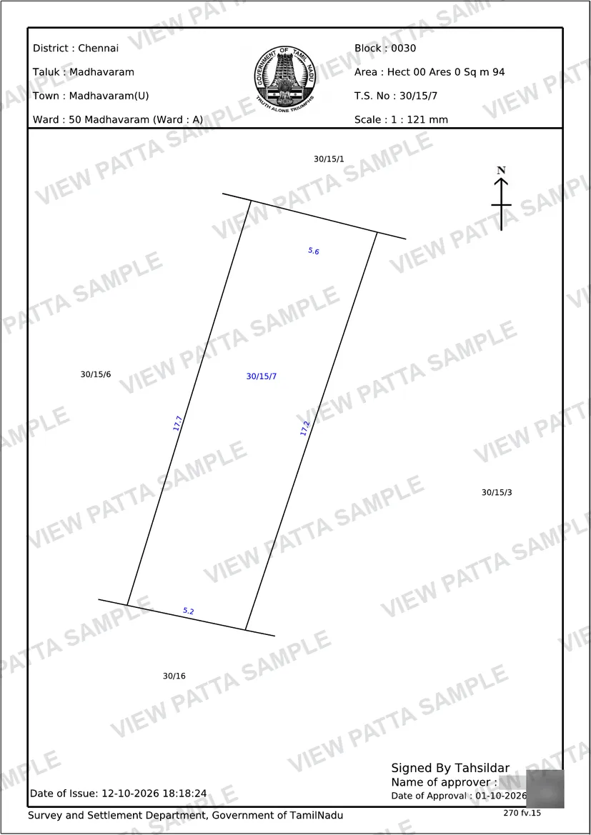
- Seeing where an urban plot sits in its block before ordering a TSLR extract
- Finding the T.S. numbers next to the one on a sale deed or tax receipt
- Locating the streets and neighbouring plots around a town property
Overview
Block Map overview
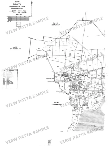
A Block Map (பிளாக் வரைபடம்) is a town-survey cadastral map: one drawing of a block within a town ward, with every town survey (T.S.) number laid out where it was surveyed, beside the streets and neighbouring plots around it. Towns in Tamil Nadu were surveyed ward by ward and block by block, and a T.S. number is unique only inside its ward and block, so this is the map to open when you want to see where an urban plot sits before reading its TSLR extract. View Patta delivers the original PDF sheets of the Tamil Nadu survey map: one PDF for a one-sheet set, and a ZIP of PDFs for a multi-sheet set. You choose the district, taluk, town, ward and block; no T.S. number is asked for. Places are listed by their names on the survey map, which can differ from today’s, and a town the survey map does not divide into wards lists a single ward, shown as “-”. The map shows boundaries as they were surveyed, not ownership and not current sub-divisions. This is an information copy, never a certified copy or proof of title.
Record guide
What do the terms mean?
- Town survey
- The survey of a town ward by ward and block by block. Its register is the TSLR; its numbers are T.S. numbers.
- Ward and block
- A town is divided into wards and each ward into blocks. A town the survey map does not divide into wards lists a single ward, “-”, which holds its blocks.
- T.S. number
- The identifier of a plot within its ward and block. The same number can recur in another block, so the block is part of the address.
- Map sheet
- One PDF page of the block map. A one-sheet set arrives as one PDF; a multi-sheet set arrives as a ZIP of PDFs.
- As surveyed
- The map shows the land as it was surveyed, which may differ from today. It is not a new survey.
Troubleshooting
Why might the result not appear?
- The town or ward is listed under an older label than the one on your land document.
- The block on a tax receipt or deed is numbered differently from the survey map’s block label.
- The map is expected to show today’s buildings, but it shows the survey as recorded.
- A plot’s exact measurements are needed, which a block-wide drawing does not give.
- The map is expected to show who holds each plot, but it shows T.S. numbers and boundaries only.
What this record cannot establish
A Block Map is an information copy of a survey map. It shows boundaries as they were surveyed. It does not by itself establish ownership, possession, current sub-divisions or what stands on the land today, and it is not a certified copy or proof of title. Use the TSLR extract for a plot’s recorded details and the TSLR sketch for its drawing, and ask a licensed surveyor to resolve any boundary difference on site.
Verification checklist
How to use this record
- Choose the district, taluk, town, ward and block as the survey map lists them; the labels can be older than today’s names.
- Open every sheet in the delivered PDF or ZIP, since a large block is split across several.
- Find the T.S. number from your document and note the streets and neighbouring plots beside it.
- Compare that position with your land document and with the site.
- Check the plot’s recorded details in its TSLR extract and its drawing in the TSLR sketch before relying on either.
Search help
What details should you keep ready?
Type the town, or pick the district, taluk, town, ward and block as the survey map lists them. No T.S. number is needed; the map covers the whole block. A town or ward can carry an older label than the one on your document.
Guides
Read before you search
Related tools
Continue checking the property
Questions
Before you start.
Including the two most people ask: whether we are the government, and what happens if the record is not there.
What is a Block Map?
A Block Map is a town-survey cadastral map: one drawing of a block within a town ward, showing every town survey number where it was surveyed, with the streets and neighbouring plots around it.
What do I need to order one?
The district, taluk, town, ward and block. No T.S. number is asked for, because the map covers the whole block. Type the town to find it, or choose each level from the list on this page.
My town has no ward. Can I still order a block?
Yes. Some towns are not divided into wards on the survey map. Their ward list shows a single “-”, which is chosen for you; then choose the block.
When do I pay?
Checking whether the map sheets are held costs nothing. A price appears only once the sheets are ready, and you pay after that. A block with no map held shows as not available and costs nothing.
What do I receive?
The original PDF sheets of the survey map. A one-sheet set arrives as one PDF, and a multi-sheet set arrives as a ZIP of PDFs. It is not a spreadsheet, a certificate or a TSLR extract.
What is the difference between a Block Map and a TSLR extract?
A Block Map covers a whole block in one drawing, so you can see how every T.S. number sits together. A TSLR extract is the register entry for one T.S. number, with its recorded details.
Does a Block Map show today’s buildings or who owns a plot?
No. It shows boundaries as they were surveyed, not ownership, buildings or current sub-divisions. For a plot’s recorded details, use its TSLR extract.
Is a Block Map a certified copy or proof of title?
No. It is an information copy of a survey map, not a certified copy or proof of title. Check ownership against the registered deed and the other records for the plot.
Is View Patta a government website?
No. View Patta is a private service operated by Quiro Tech Solutions, Chennai. We are not affiliated with any government body. Revenue-record services are available through Tamil Nadu e-Services; Encumbrance Certificates are registration records available through TNREGINET. View Patta provides separate assistance with finding and requesting these records.
What happens if you cannot find my record?
No record, no charge. Your money stays yours.
For a single record we look first and only ask for payment once we hold a complete, readable record for your survey number. If the portal has no record, returns something incomplete, or does not respond, you see exactly what happened and you are not charged.
A village report is paid for first, because it is compiled after you order. If it cannot be compiled, the payment is refunded in full, automatically.